


Mongenevre

Léger Michel
User
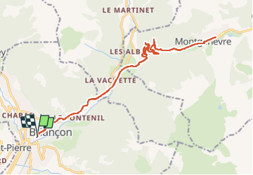

Length
24 km

Max alt
1857 m

Uphill gradient
741 m
Km-Effort
34 km

Min alt
1225 m

Downhill gradient
730 m
Boucle
Yes
Creation date :
2023-03-03 09:42:40.559
Updated on :
2023-03-03 11:50:26.516
2h05
Difficulty : Difficult

FREE GPS app for hiking
 SityTrail
IGN / Geographical institutes
SityTrail Plus
The world is yours!
About
Trail Road bike of 24 km to be discovered at Provence-Alpes-Côte d'Azur, Hautes-Alpes, Briançon. This trail is proposed by Léger Michel.
Positioning
Country:
France
Region :
Provence-Alpes-Côte d'Azur
Department/Province :
Hautes-Alpes
Municipality :
Briançon
Location:
Unknown
Start:(Dec)
Start:(UTM)
313432 ; 4974167 (32T) N.
Comments