


gy en Sologne

lecmic
User
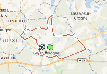

Length
18.3 km

Max alt
116 m

Uphill gradient
151 m
Km-Effort
20 km

Min alt
80 m

Downhill gradient
153 m
Boucle
Yes
Creation date :
2023-03-05 06:22:26.008
Updated on :
2023-03-05 09:31:31.53
3h08
Difficulty : Easy

FREE GPS app for hiking
 SityTrail
IGN / Geographical institutes
SityTrail Plus
The world is yours!
About
Trail Walking of 18.3 km to be discovered at Centre-Loire Valley, Loir-et-Cher, Gy-en-Sologne. This trail is proposed by lecmic.
Description
rando de printemps
Positioning
Country:
France
Region :
Centre-Loire Valley
Department/Province :
Loir-et-Cher
Municipality :
Gy-en-Sologne
Location:
Unknown
Start:(Dec)
Start:(UTM)
392985 ; 5244338 (31T) N.
Comments