


cheverny 12 8

Rolland Jean Pierre
User
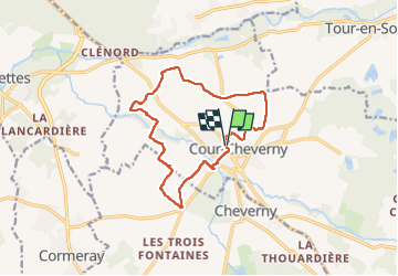

Length
12.8 km

Max alt
106 m

Uphill gradient
93 m
Km-Effort
14 km

Min alt
78 m

Downhill gradient
93 m
Boucle
Yes
Creation date :
2023-03-05 07:35:53.368
Updated on :
2023-03-05 10:35:16.451
2h58
Difficulty : Difficult

FREE GPS app for hiking
 SityTrail
IGN / Geographical institutes
SityTrail Plus
The world is yours!
About
Trail Walking of 12.8 km to be discovered at Centre-Loire Valley, Loir-et-Cher, Cour-Cheverny. This trail is proposed by Rolland Jean Pierre .
Positioning
Country:
France
Region :
Centre-Loire Valley
Department/Province :
Loir-et-Cher
Municipality :
Cour-Cheverny
Location:
Unknown
Start:(Dec)
Start:(UTM)
383687 ; 5263380 (31T) N.
Comments