


De doode bemde Nerijse

drkb
User
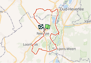

Length
17 km

Max alt
93 m

Uphill gradient
204 m
Km-Effort
19.7 km

Min alt
23 m

Downhill gradient
208 m
Boucle
Yes
Creation date :
2023-03-05 09:36:31.218
Updated on :
2023-03-05 14:02:38.667
3h58
Difficulty : Medium

FREE GPS app for hiking
 SityTrail
IGN / Geographical institutes
SityTrail Plus
The world is yours!
About
Trail Walking of 17 km to be discovered at Flanders, Flemish Brabant, Huldenberg. This trail is proposed by drkb.
Positioning
Country:
Belgium
Region :
Flanders
Department/Province :
Flemish Brabant
Municipality :
Huldenberg
Location:
Neerijse
Start:(Dec)
Start:(UTM)
614479 ; 5630778 (31U) N.
Comments