


les grilloux. 2

jacthiry
User
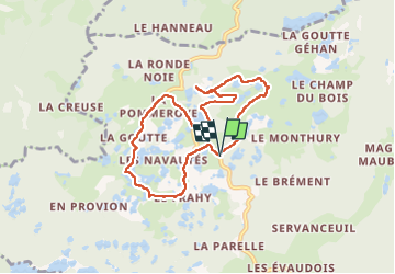

Length
7.5 km

Max alt
656 m

Uphill gradient
98 m
Km-Effort
8.8 km

Min alt
601 m

Downhill gradient
102 m
Boucle
Yes
Creation date :
2023-03-05 11:15:37.122
Updated on :
2023-03-05 14:31:08.149
2h16
Difficulty : Medium

FREE GPS app for hiking
 SityTrail
IGN / Geographical institutes
SityTrail Plus
The world is yours!
About
Trail Walking of 7.5 km to be discovered at Bourgogne-Franche-Comté, Haute-Saône, Servance-Miellin. This trail is proposed by jacthiry.
Positioning
Country:
France
Region :
Bourgogne-Franche-Comté
Department/Province :
Haute-Saône
Municipality :
Servance-Miellin
Location:
Servance
Start:(Dec)
Start:(UTM)
325446 ; 5300993 (32T) N.
Comments