


Castano de Rebledo

taguette
User
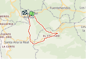

Length
14.4 km

Max alt
831 m

Uphill gradient
398 m
Km-Effort
19.7 km

Min alt
524 m

Downhill gradient
408 m
Boucle
Yes
Creation date :
2023-03-06 09:09:10.703
Updated on :
2023-03-06 12:56:14.36
3h44
Difficulty : Medium

FREE GPS app for hiking
 SityTrail
IGN / Geographical institutes
SityTrail Plus
The world is yours!
About
Trail Walking of 14.4 km to be discovered at Andalusia, Huelva, Castaño del Robledo. This trail is proposed by taguette.
Positioning
Country:
Spain
Region :
Andalusia
Department/Province :
Huelva
Municipality :
Castaño del Robledo
Location:
Unknown
Start:(Dec)
Start:(UTM)
701640 ; 4196182 (29S) N.
Comments