


volcan San Antonio La Palma

Vinceneux
User
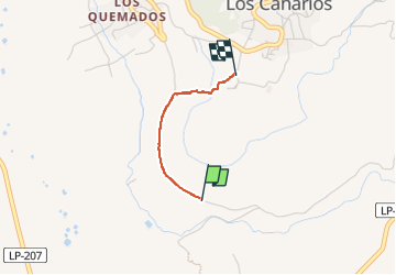

Length
1.6 km

Max alt
645 m

Uphill gradient
192 m
Km-Effort
3.6 km

Min alt
446 m

Downhill gradient
0 m
Boucle
No
Creation date :
2023-03-06 12:26:06.472
Updated on :
2023-03-06 13:11:35.474
45m
Difficulty : Easy

FREE GPS app for hiking
 SityTrail
IGN / Geographical institutes
SityTrail Plus
The world is yours!
About
Trail Walking of 1.6 km to be discovered at Canary Islands, Santa Cruz de Tenerife. This trail is proposed by Vinceneux.
Positioning
Country:
Spain
Region :
Canary Islands
Department/Province :
Santa Cruz de Tenerife
Municipality :
Unknown
Location:
Unknown
Start:(Dec)
Start:(UTM)
220905 ; 3153587 (28R) N.
Comments