


Col de Joux - Gerbier de Jonc

Shadowfax
User
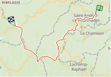

Length
13.9 km

Max alt
1452 m

Uphill gradient
581 m
Km-Effort
20 km

Min alt
1002 m

Downhill gradient
172 m
Boucle
No
Creation date :
2023-03-07 09:56:33.429
Updated on :
2023-03-07 09:57:23.845
4h36
Difficulty : Very difficult

FREE GPS app for hiking
 SityTrail
IGN / Geographical institutes
SityTrail Plus
The world is yours!
About
Trail Walking of 13.9 km to be discovered at Auvergne-Rhône-Alpes, Ardèche, Saint-Andéol-de-Fourchades. This trail is proposed by Shadowfax.
Positioning
Country:
France
Region :
Auvergne-Rhône-Alpes
Department/Province :
Ardèche
Municipality :
Saint-Andéol-de-Fourchades
Location:
Unknown
Start:(Dec)
Start:(UTM)
603398 ; 4967188 (31T) N.
Comments