


Le chemin des chasseurs Tornac

JMJ42
User
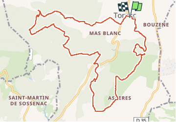

Length
14.7 km

Max alt
293 m

Uphill gradient
308 m
Km-Effort
18.8 km

Min alt
133 m

Downhill gradient
305 m
Boucle
Yes
Creation date :
2023-03-07 08:17:45.423
Updated on :
2023-03-07 14:09:45.023
3h52
Difficulty : Medium

FREE GPS app for hiking
 SityTrail
IGN / Geographical institutes
SityTrail Plus
The world is yours!
About
Trail Walking of 14.7 km to be discovered at Occitania, Gard, Tornac. This trail is proposed by JMJ42.
Positioning
Country:
France
Region :
Occitania
Department/Province :
Gard
Municipality :
Tornac
Location:
Unknown
Start:(Dec)
Start:(UTM)
580011 ; 4874825 (31T) N.
Comments