


1 étang cesson

Pascal Gueno
User
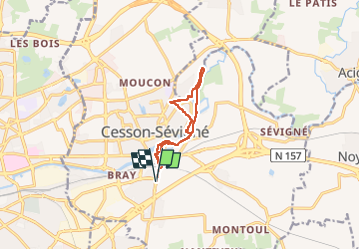

Length
9.2 km

Max alt
49 m

Uphill gradient
81 m
Km-Effort
10.3 km

Min alt
26 m

Downhill gradient
81 m
Boucle
Yes
Creation date :
2023-03-07 12:57:46.988
Updated on :
2023-03-07 15:03:29.631
1h58
Difficulty : Medium

FREE GPS app for hiking
 SityTrail
IGN / Geographical institutes
SityTrail Plus
The world is yours!
About
Trail Walking of 9.2 km to be discovered at Brittany, Ille-et-Vilaine, Cesson-Sévigné. This trail is proposed by Pascal Gueno.
Description
randonnée
Positioning
Country:
France
Region :
Brittany
Department/Province :
Ille-et-Vilaine
Municipality :
Cesson-Sévigné
Location:
Unknown
Start:(Dec)
Start:(UTM)
603983 ; 5329293 (30U) N.
Comments