


CALVISSON sud 2023-03-07

rando30129
User
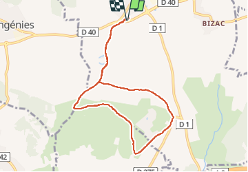

Length
9 km

Max alt
84 m

Uphill gradient
91 m
Km-Effort
10.2 km

Min alt
32 m

Downhill gradient
92 m
Boucle
Yes
Creation date :
2023-03-07 13:06:38.614
Updated on :
2023-03-13 06:35:43.73
2h21
Difficulty : Medium

FREE GPS app for hiking
 SityTrail
IGN / Geographical institutes
SityTrail Plus
The world is yours!
About
Trail Walking of 9 km to be discovered at Occitania, Gard, Calvisson. This trail is proposed by rando30129.
Positioning
Country:
France
Region :
Occitania
Department/Province :
Gard
Municipality :
Calvisson
Location:
Unknown
Start:(Dec)
Start:(UTM)
595740 ; 4847907 (31T) N.
Comments