


l'amarron par gareoult vincent

bernir
User
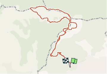

Length
13.5 km

Max alt
769 m

Uphill gradient
569 m
Km-Effort
21 km

Min alt
415 m

Downhill gradient
564 m
Boucle
Yes
Creation date :
2023-03-09 08:34:06.847
Updated on :
2023-03-10 09:04:52.938
6h03
Difficulty : Difficult

FREE GPS app for hiking
 SityTrail
IGN / Geographical institutes
SityTrail Plus
The world is yours!
About
Trail Walking of 13.5 km to be discovered at Provence-Alpes-Côte d'Azur, Var, Garéoult. This trail is proposed by bernir.
Positioning
Country:
France
Region :
Provence-Alpes-Côte d'Azur
Department/Province :
Var
Municipality :
Garéoult
Location:
Unknown
Start:(Dec)
Start:(UTM)
259564 ; 4803348 (32T) N.
Comments