


SityTrail - SityTrail - depart quingey vers abbans dessous; abbans dessus

gerardmicheline
User
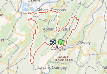

Length
21 km

Max alt
523 m

Uphill gradient
608 m
Km-Effort
29 km

Min alt
220 m

Downhill gradient
606 m
Boucle
Yes
Creation date :
2023-03-10 12:19:34.467
Updated on :
2023-03-10 12:37:08.843
6h36
Difficulty : Very difficult

FREE GPS app for hiking
 SityTrail
IGN / Geographical institutes
SityTrail Plus
The world is yours!
About
Trail Walking of 21 km to be discovered at Bourgogne-Franche-Comté, Doubs, Quingey. This trail is proposed by gerardmicheline.
Positioning
Country:
France
Region :
Bourgogne-Franche-Comté
Department/Province :
Doubs
Municipality :
Quingey
Location:
Unknown
Start:(Dec)
Start:(UTM)
718696 ; 5220697 (31T) N.
Comments