


Balade vers Mont thou

GioA10
User
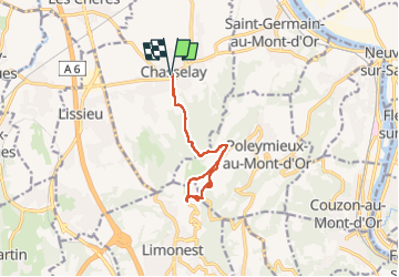

Length
10.9 km

Max alt
602 m

Uphill gradient
394 m
Km-Effort
16.2 km

Min alt
233 m

Downhill gradient
395 m
Boucle
Yes
Creation date :
2023-03-10 09:33:09.0
Updated on :
2023-03-10 13:12:10.096
3h00
Difficulty : Easy

FREE GPS app for hiking
 SityTrail
IGN / Geographical institutes
SityTrail Plus
The world is yours!
About
Trail Walking of 10.9 km to be discovered at Auvergne-Rhône-Alpes, Rhône, Chasselay. This trail is proposed by GioA10.
Positioning
Country:
France
Region :
Auvergne-Rhône-Alpes
Department/Province :
Rhône
Municipality :
Chasselay
Location:
Unknown
Start:(Dec)
Start:(UTM)
637425 ; 5081525 (31T) N.
Comments