


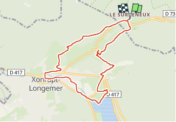
XONRUPT LONGEMER ROCHE DU PAGE

surceneux
User

Length
9.4 km

Max alt
868 m

Uphill gradient
200 m
Km-Effort
12 km

Min alt
718 m

Downhill gradient
198 m
Boucle
Yes
Creation date :
2023-03-10 14:58:08.597
Updated on :
2023-03-10 17:47:48.527
1h50
Difficulty : Easy

FREE GPS app for hiking
 SityTrail
IGN / Geographical institutes
SityTrail Plus
The world is yours!
About
Trail Walking of 9.4 km to be discovered at Grand Est, Vosges, Ban-sur-Meurthe-Clefcy. This trail is proposed by surceneux.
Description
SURCENEUX LONGEMER XONRUPT CENTRE LES FIES LA ROCHE DU PAGE RF BEHEUILLE SURCENEUX
Positioning
Country:
France
Region :
Grand Est
Department/Province :
Vosges
Municipality :
Ban-sur-Meurthe-Clefcy
Location:
Unknown
Start:(Dec)
Start:(UTM)
347845 ; 5329048 (32U) N.
Comments