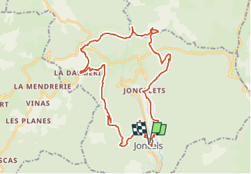
Joncels La Dalmerie Les Cabrils La Borie Noble La Flaissière Joncelet

Alain28/01
User

Length
22 km

Max alt
709 m

Uphill gradient
685 m
Km-Effort
31 km

Min alt
342 m

Downhill gradient
689 m
Boucle
Yes
Creation date :
2023-03-10 18:08:59.104
Updated on :
2023-03-10 18:11:46.082
7h01
Difficulty : Very difficult

FREE GPS app for hiking
 SityTrail
IGN / Geographical institutes
SityTrail Plus
The world is yours!
About
Trail Walking of 22 km to be discovered at Occitania, Hérault, Joncels. This trail is proposed by Alain28/01.
Positioning
Country:
France
Region :
Occitania
Department/Province :
Hérault
Municipality :
Joncels
Location:
Unknown
Start:(Dec)
Start:(UTM)
515648 ; 4842774 (31T) N.
Comments