


Mur de Sologne

lecmic
User
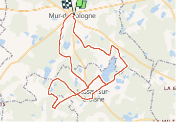

Length
24 km

Max alt
119 m

Uphill gradient
188 m
Km-Effort
26 km

Min alt
88 m

Downhill gradient
188 m
Boucle
Yes
Creation date :
2023-03-12 06:06:44.728
Updated on :
2023-03-12 10:23:46.951
4h11
Difficulty : Easy

FREE GPS app for hiking
 SityTrail
IGN / Geographical institutes
SityTrail Plus
The world is yours!
About
Trail Walking of 24 km to be discovered at Centre-Loire Valley, Loir-et-Cher, Mur-de-Sologne. This trail is proposed by lecmic.
Description
rando du boudin
Positioning
Country:
France
Region :
Centre-Loire Valley
Department/Province :
Loir-et-Cher
Municipality :
Mur-de-Sologne
Location:
Unknown
Start:(Dec)
Start:(UTM)
395118 ; 5251946 (31T) N.
Comments