


SM_ROSIERES-NORD_8.6Km

GR77LP
User
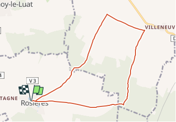

Length
8.6 km

Max alt
159 m

Uphill gradient
93 m
Km-Effort
9.9 km

Min alt
82 m

Downhill gradient
92 m
Boucle
Yes
Creation date :
2023-03-12 14:29:57.025
Updated on :
2023-03-12 14:32:03.577
2h14
Difficulty : Medium

FREE GPS app for hiking
 SityTrail
IGN / Geographical institutes
SityTrail Plus
The world is yours!
About
Trail Walking of 8.6 km to be discovered at Hauts-de-France, Oise. This trail is proposed by GR77LP.
Description
https//www.goelerando.fr DAMMARTIN en GOËLE 77230
Photos

Positioning
Country:
France
Region :
Hauts-de-France
Department/Province :
Oise
Municipality :
Unknown
Location:
Unknown
Start:(Dec)
Start:(UTM)
483844 ; 5448455 (31U) N.
Comments