


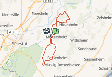
2023-03-12 Picnic CVA Muttersholtz

holtzv
User GUIDE


4h41
Difficulty : Easy

FREE GPS app for hiking
 SityTrail
IGN / Geographical institutes
SityTrail Plus
The world is yours!
About
Trail Horseback riding of 30 km to be discovered at Grand Est, Bas-Rhin, Muttersholtz. This trail is proposed by holtzv.
Description
Balade à la journée sous forme d’un huit au départ de Muttersholtz et en passant le matin par Baldenheim et Mussig, retour pour prendre le repas au Nord de Muttersholtz en passant par la digne, et après-midi non loin d’Hilsenheim. Une météo clémente pour retrouver les beaux coins du Ried propices aux allures.
Positioning
Comments