


Eaunes fait 20230312

pidjam
User

Length
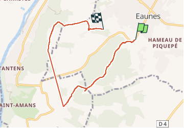
8.8 km

Max alt
308 m

Uphill gradient
185 m
Km-Effort
11.2 km

Min alt
208 m

Downhill gradient
176 m
Boucle
Yes
Creation date :
2023-03-12 13:00:43.701
Updated on :
2024-11-01 17:37:34.906
2h33
Difficulty : Medium

FREE GPS app for hiking
 SityTrail
IGN / Geographical institutes
SityTrail Plus
The world is yours!
About
Trail Walking of 8.8 km to be discovered at Occitania, Haute-Garonne, Eaunes. This trail is proposed by pidjam.
Positioning
Country:
France
Region :
Occitania
Department/Province :
Haute-Garonne
Municipality :
Eaunes
Location:
Unknown
Start:(Dec)
Start:(UTM)
366652 ; 4808651 (31T) N.
Comments