Trail Walking Montreuil-sur-Blaise - Montreuil sur Blaise - Photo
© OpenStreetMap contributors
Length
Length
9.5 km
Max alt
Max alt
218 m
Uphill gradient
Uphill gradient
109 m
Km-Effort
Km-Effort  
11 km
Min alt
Min alt
168 m
Downhill gradient
Downhill gradient
110 m
Boucle
Boucle
Yes
Creation date :
2023-03-12 12:45:13.0
Updated on :
2023-03-12 16:32:10.128

(0 Reviews)

Walking
Walking
3h45
Difficulty : Unknown

Scan this QR Code to open this trail in the SityTrail application

FREE GPS app for hiking

Logo SityTrail SityTrail

IGN / Geographical institutes

Download SityTrail from the App Store Download SityTrail from Google Play

Logo SityTrail SityTrail World

The world is yours!

Download SityTrail from the App Store Download SityTrail from Google Play Download SityTrail on Huawei AppGallery

About

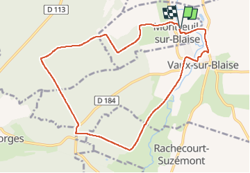
Trail Walking of 9.5 km to be discovered at Grand Est, Haute-Marne, Montreuil-sur-Blaise. This trail is proposed by René Kovac.

Description

Place des Tilleuls

Elevation profile

Positioning

Country:
France
Region :
Grand Est
Department/Province :
Haute-Marne
Municipality :
Montreuil-sur-Blaise
Location:
Unknown
Start:(UTM)
645164 ; 5371222 (31U) N.

Trails nearby

Trail Walking Wassy - Pont Varin église  - Photo
Walking
René Kovac

Walking

Wassy, Grand Est, Haute-Marne, France
9.8 km | 11.1 km-effort
2h 43min
No
Trail Running Wassy - Le_Picard_Haut-Marnais.gpx - Photo
Running
Alain Chevalier

Running

Easy
Wassy, Grand Est, Haute-Marne, France
22 km | 25 km-effort
Unknown
No


Close
My subscriptions