


pernes ravin de Labat

aupi
User
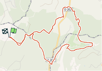

Length
7.5 km

Max alt
273 m

Uphill gradient
176 m
Km-Effort
9.8 km

Min alt
172 m

Downhill gradient
176 m
Boucle
Yes
Creation date :
2023-02-26 13:16:57.091
Updated on :
2023-03-13 06:59:51.176
2h59
Difficulty : Medium

FREE GPS app for hiking
 SityTrail
IGN / Geographical institutes
SityTrail Plus
The world is yours!
About
Trail Walking of 7.5 km to be discovered at Provence-Alpes-Côte d'Azur, Vaucluse, L'Isle-sur-la-Sorgue. This trail is proposed by aupi.
Positioning
Country:
France
Region :
Provence-Alpes-Côte d'Azur
Department/Province :
Vaucluse
Municipality :
L'Isle-sur-la-Sorgue
Location:
Unknown
Start:(Dec)
Start:(UTM)
666443 ; 4869600 (31T) N.
Comments