


Luc 2

bouscaillou
User
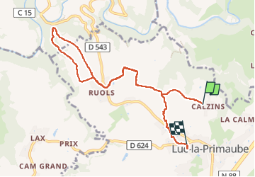

Length
9.8 km

Max alt
679 m

Uphill gradient
230 m
Km-Effort
12.8 km

Min alt
577 m

Downhill gradient
206 m
Boucle
No
Creation date :
2023-03-13 13:12:33.822
Updated on :
2023-03-13 15:26:26.985
2h13
Difficulty : Difficult

FREE GPS app for hiking
 SityTrail
IGN / Geographical institutes
SityTrail Plus
The world is yours!
About
Trail Walking of 9.8 km to be discovered at Occitania, Aveyron, Luc-la-Primaube. This trail is proposed by bouscaillou.
Positioning
Country:
France
Region :
Occitania
Department/Province :
Aveyron
Municipality :
Luc-la-Primaube
Location:
Unknown
Start:(Dec)
Start:(UTM)
462739 ; 4907751 (31T) N.
Comments