


Mauvezin-Hobio-14446683

pidjam
User
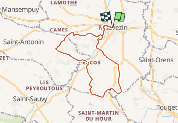

Length
16.2 km

Max alt
201 m

Uphill gradient
309 m
Km-Effort
20 km

Min alt
126 m

Downhill gradient
309 m
Boucle
Yes
Creation date :
2023-03-14 13:14:19.474
Updated on :
2023-03-14 13:22:29.79
4h36
Difficulty : Very difficult

FREE GPS app for hiking
 SityTrail
IGN / Geographical institutes
SityTrail Plus
The world is yours!
About
Trail Walking of 16.2 km to be discovered at Occitania, Gers, Mauvezin. This trail is proposed by pidjam.
Positioning
Country:
France
Region :
Occitania
Department/Province :
Gers
Municipality :
Mauvezin
Location:
Unknown
Start:(Dec)
Start:(UTM)
329073 ; 4844114 (31T) N.
Comments