


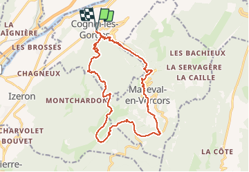
F26 ST LCV COGNIN MALLEVAL LUNETTE N2 ANIM

ageo
User

Length
21 km

Max alt
1322 m

Uphill gradient
1245 m
Km-Effort
37 km

Min alt
275 m

Downhill gradient
1246 m
Boucle
Yes
Creation date :
2017-06-06 00:00:00.0
Updated on :
2017-06-06 00:00:00.0
6h23
Difficulty : Medium

FREE GPS app for hiking
 SityTrail
IGN / Geographical institutes
SityTrail Plus
The world is yours!
About
Trail Walking of 21 km to be discovered at Auvergne-Rhône-Alpes, Isère, Cognin-les-Gorges. This trail is proposed by ageo.
Description
Quelques passages glissants si pluie.
Positioning
Country:
France
Region :
Auvergne-Rhône-Alpes
Department/Province :
Isère
Municipality :
Cognin-les-Gorges
Location:
Unknown
Start:(Dec)
Start:(UTM)
689564 ; 5004719 (31T) N.
Comments