


foret d Évreux

JamesVautier
User
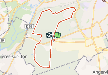

Length
8.6 km

Max alt
147 m

Uphill gradient
80 m
Km-Effort
9.7 km

Min alt
110 m

Downhill gradient
81 m
Boucle
Yes
Creation date :
2023-03-14 12:45:58.29
Updated on :
2023-03-14 16:32:17.116
3h45
Difficulty : Very easy

FREE GPS app for hiking
 SityTrail
IGN / Geographical institutes
SityTrail Plus
The world is yours!
About
Trail Walking of 8.6 km to be discovered at Normandy, Eure, Évreux. This trail is proposed by JamesVautier.
Description
très sympa 👍😉
Positioning
Country:
France
Region :
Normandy
Department/Province :
Eure
Municipality :
Évreux
Location:
Unknown
Start:(Dec)
Start:(UTM)
363207 ; 5429360 (31U) N.
Comments