


sete

CASSISFRAMBOISE
User
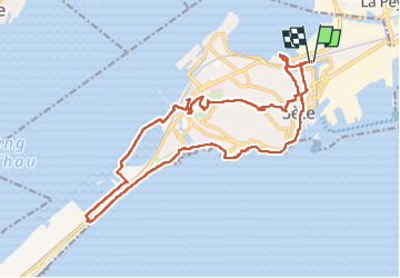

Length
23 km

Max alt
176 m

Uphill gradient
280 m
Km-Effort
26 km

Min alt
-8 m

Downhill gradient
281 m
Boucle
Yes
Creation date :
2023-03-14 09:04:41.619
Updated on :
2023-03-14 16:47:54.118
5h28
Difficulty : Medium

FREE GPS app for hiking
 SityTrail
IGN / Geographical institutes
SityTrail Plus
The world is yours!
About
Trail Walking of 23 km to be discovered at Occitania, Hérault, Sète. This trail is proposed by CASSISFRAMBOISE.
Positioning
Country:
France
Region :
Occitania
Department/Province :
Hérault
Municipality :
Sète
Location:
Unknown
Start:(Dec)
Start:(UTM)
556734 ; 4806907 (31T) N.
Comments