


rouviere

tosan
User
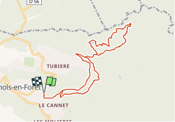

Length
11 km

Max alt
328 m

Uphill gradient
289 m
Km-Effort
14.9 km

Min alt
180 m

Downhill gradient
290 m
Boucle
Yes
Creation date :
2023-03-14 17:29:44.321
Updated on :
2023-03-14 17:29:46.067
3h23
Difficulty : Difficult

FREE GPS app for hiking
 SityTrail
IGN / Geographical institutes
SityTrail Plus
The world is yours!
About
Trail Walking of 11 km to be discovered at Provence-Alpes-Côte d'Azur, Var, Bagnols-en-Forêt. This trail is proposed by tosan.
Positioning
Country:
France
Region :
Provence-Alpes-Côte d'Azur
Department/Province :
Var
Municipality :
Bagnols-en-Forêt
Location:
Unknown
Start:(Dec)
Start:(UTM)
314925 ; 4822908 (32T) N.
Comments