


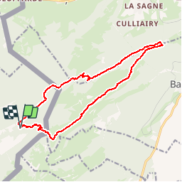
Aiguilles de Baulmes - Suisse

albert39
User


5h33
Difficulty : Difficult

FREE GPS app for hiking
 SityTrail
IGN / Geographical institutes
SityTrail Plus
The world is yours!
About
Trail Walking of 16.4 km to be discovered at Bourgogne-Franche-Comté, Doubs, Jougne. This trail is proposed by albert39.
Description
Rando RSGD, animateur Michel - Départ chalet Refuge de la Queue, Col de l'Aiguillon, montée à la croix (pose et casse-croûte), direction Mont des Aiguilles, au Puits de Jacob descente par la forêt de Gremecé vers le plateau de Baumine, chalet Grange-Neuve, Gorges La Roche Marquée, Ruisseau du Petit Nerveau et parking.
Positioning
Comments
Magnifique rando, soleil et cadre splendide.