


balade locquignol

brunobuj
User
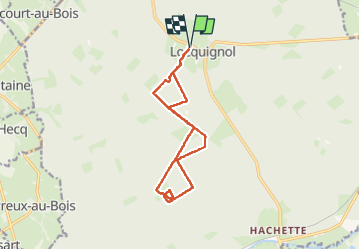

Length
11.8 km

Max alt
178 m

Uphill gradient
147 m
Km-Effort
13.7 km

Min alt
146 m

Downhill gradient
147 m
Boucle
Yes
Creation date :
2023-03-15 13:36:25.095
Updated on :
2023-03-15 16:14:03.237
2h37
Difficulty : Difficult

FREE GPS app for hiking
 SityTrail
IGN / Geographical institutes
SityTrail Plus
The world is yours!
About
Trail Walking of 11.8 km to be discovered at Hauts-de-France, Nord, Locquignol. This trail is proposed by brunobuj.
Positioning
Country:
France
Region :
Hauts-de-France
Department/Province :
Nord
Municipality :
Locquignol
Location:
Unknown
Start:(Dec)
Start:(UTM)
550853 ; 5561062 (31U) N.
Comments