


breuillet souzy breuillet

olivieraron
User
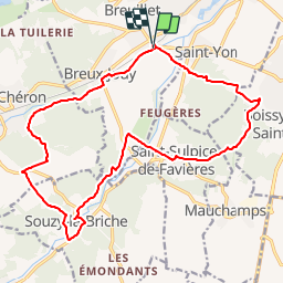

Length
18.8 km

Max alt
158 m

Uphill gradient
349 m
Km-Effort
23 km

Min alt
56 m

Downhill gradient
350 m
Boucle
Yes
Creation date :
2019-01-14 09:46:13.739
Updated on :
2019-01-14 09:46:14.177
4h20
Difficulty : Unknown

FREE GPS app for hiking
 SityTrail
IGN / Geographical institutes
SityTrail Plus
The world is yours!
About
Trail Other activity of 18.8 km to be discovered at Ile-de-France, Essonne, Breuillet. This trail is proposed by olivieraron.
Positioning
Country:
France
Region :
Ile-de-France
Department/Province :
Essonne
Municipality :
Breuillet
Location:
Unknown
Start:(Dec)
Start:(UTM)
438876 ; 5379359 (31U) N.
Comments