


Oberhaslach Croix de Saverne

oscar1
User
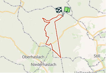

Length
12.2 km

Max alt
529 m

Uphill gradient
351 m
Km-Effort
16.8 km

Min alt
261 m

Downhill gradient
351 m
Boucle
Yes
Creation date :
2023-03-16 08:45:48.015
Updated on :
2023-03-16 20:06:56.001
3h06
Difficulty : Very easy

FREE GPS app for hiking
 SityTrail
IGN / Geographical institutes
SityTrail Plus
The world is yours!
About
Trail Walking of 12.2 km to be discovered at Grand Est, Bas-Rhin, Still. This trail is proposed by oscar1.
Positioning
Country:
France
Region :
Grand Est
Department/Province :
Bas-Rhin
Municipality :
Still
Location:
Unknown
Start:(Dec)
Start:(UTM)
379392 ; 5382292 (32U) N.
Comments