Trail Walking Rethonvillers - Jose 800 - Photo
 José800
José800

User

© OpenStreetMap contributors
Length
Length
11.3 km
Max alt
Max alt
93 m
Uphill gradient
Uphill gradient
42 m
Km-Effort
Km-Effort  
11.9 km
Min alt
Min alt
79 m
Downhill gradient
Downhill gradient
42 m
Boucle
Boucle
Yes
Creation date :
2023-03-16 12:52:55.963
Updated on :
2023-03-16 16:20:46.765

(0 Reviews)

Walking
Walking
2h43
Difficulty : Medium

Scan this QR Code to open this trail in the SityTrail application

FREE GPS app for hiking

Logo SityTrail SityTrail

IGN / Geographical institutes

Download SityTrail from the App Store Download SityTrail from Google Play

Logo SityTrail SityTrail World

The world is yours!

Download SityTrail from the App Store Download SityTrail from Google Play Download SityTrail on Huawei AppGallery

About

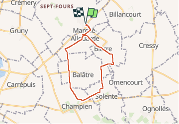
Trail Walking of 11.3 km to be discovered at Hauts-de-France, Somme, Rethonvillers. This trail is proposed by José800.

Description

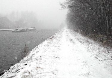
circuit le fond de Biarre à  Rethonvillers 80 , 11,300 kms .un beau circuit dans la campagne et villages .

Elevation profile

Positioning

Country:
France
Region :
Hauts-de-France
Department/Province :
Somme
Municipality :
Rethonvillers
Location:
Unknown
Start:(UTM)
490439 ; 5508849 (31U) N.

Trails nearby

Trail Walking Curchy - Circuit de l'Ingon - Curchy - Photo
Walking
tracegps

Walking

Medium
Curchy, Hauts-de-France, Somme, France
9.7 km | 10.7 km-effort
2h 30min
Yes
Trail Walking Nesle - Circuit de la fontaine Saint Quentin - Nesle - Photo
Walking
tracegps

Walking

Medium
Nesle, Hauts-de-France, Somme, France
12.5 km | 13.8 km-effort
3h 10min
Yes
Trail Walking Fonches-Fonchette - Circuit de la source blanche - Fonches - Photo
Walking
tracegps

Walking

Medium
Fonches-Fonchette, Hauts-de-France, Somme, France
8.4 km | 9.2 km-effort
2h 10min
Yes
Trail Cycle Nesle - Canal du Nord et de la Somme - Photo
Cycle
tracegps

Cycle

Medium
(1)
Nesle, Hauts-de-France, Somme, France
41 km | 45 km-effort
2h 30min
Yes
Trail Walking Gruny - gruny - Photo
Walking
Christianmorel

Walking

Easy
Gruny, Hauts-de-France, Somme, France
11.3 km | 11.8 km-effort
3h 43min
No
Trail Walking Curchy - Curchy - Photo
Walking
jpblimond

Walking

Easy
Curchy, Hauts-de-France, Somme, France
17.7 km | 19.3 km-effort
4h 4min
Yes


Close
My subscriptions