


les maures des borels

bernir
User
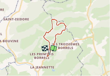

Length
11 km

Max alt
295 m

Uphill gradient
314 m
Km-Effort
15.1 km

Min alt
32 m

Downhill gradient
314 m
Boucle
Yes
Creation date :
2023-03-17 09:14:17.053
Updated on :
2023-03-18 08:20:16.36
6h29
Difficulty : Medium

FREE GPS app for hiking
 SityTrail
IGN / Geographical institutes
SityTrail Plus
The world is yours!
About
Trail Walking of 11 km to be discovered at Provence-Alpes-Côte d'Azur, Var, Hyères. This trail is proposed by bernir.
Positioning
Country:
France
Region :
Provence-Alpes-Côte d'Azur
Department/Province :
Var
Municipality :
Hyères
Location:
Unknown
Start:(Dec)
Start:(UTM)
269638 ; 4782287 (32T) N.
Comments