


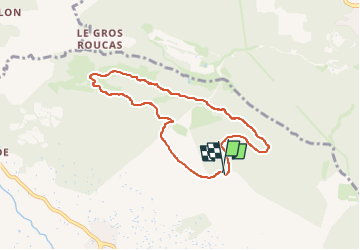
2023-3-19 Malmont, table d'orientation, ball-trap

Christianlabourie
User

Length
7.3 km

Max alt
567 m

Uphill gradient
187 m
Km-Effort
9.9 km

Min alt
482 m

Downhill gradient
194 m
Boucle
Yes
Creation date :
2023-03-19 08:38:14.906
Updated on :
2023-03-19 09:49:05.444
1h08
Difficulty : Medium

FREE GPS app for hiking
 SityTrail
IGN / Geographical institutes
SityTrail Plus
The world is yours!
About
Trail Walking of 7.3 km to be discovered at Provence-Alpes-Côte d'Azur, Var, Draguignan. This trail is proposed by Christianlabourie.
Positioning
Country:
France
Region :
Provence-Alpes-Côte d'Azur
Department/Province :
Var
Municipality :
Draguignan
Location:
Unknown
Start:(Dec)
Start:(UTM)
295286 ; 4825824 (32T) N.
Comments