


sqlagoi1

Bwattier
User
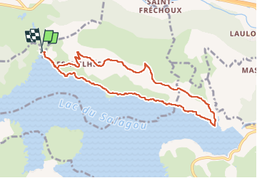

Length
9.6 km

Max alt
275 m

Uphill gradient
194 m
Km-Effort
12.2 km

Min alt
136 m

Downhill gradient
194 m
Boucle
Yes
Creation date :
2023-03-19 10:00:44.856
Updated on :
2023-03-19 13:07:36.134
2h41
Difficulty : Difficult

FREE GPS app for hiking
 SityTrail
IGN / Geographical institutes
SityTrail Plus
The world is yours!
About
Trail Walking of 9.6 km to be discovered at Occitania, Hérault, Celles. This trail is proposed by Bwattier.
Positioning
Country:
France
Region :
Occitania
Department/Province :
Hérault
Municipality :
Celles
Location:
Unknown
Start:(Dec)
Start:(UTM)
528556 ; 4835277 (31T) N.
Comments