


LD-T Forêt de la Roche Turpin

CSR-94
User
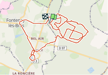

Length
16.1 km

Max alt
168 m

Uphill gradient
235 m
Km-Effort
19.2 km

Min alt
92 m

Downhill gradient
236 m
Boucle
Yes
Creation date :
2023-03-19 08:17:36.134
Updated on :
2023-03-20 21:59:43.208
5h52
Difficulty : Medium

FREE GPS app for hiking
 SityTrail
IGN / Geographical institutes
SityTrail Plus
The world is yours!
About
Trail Walking of 16.1 km to be discovered at Ile-de-France, Essonne, Bruyères-le-Châtel. This trail is proposed by CSR-94.
Positioning
Country:
France
Region :
Ile-de-France
Department/Province :
Essonne
Municipality :
Bruyères-le-Châtel
Location:
Unknown
Start:(Dec)
Start:(UTM)
439112 ; 5385442 (31U) N.
Comments