


Robion les Crêtes

Roger Philippe Wallez
User GUIDE
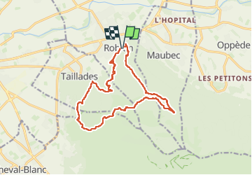

Length
16.5 km

Max alt
552 m

Uphill gradient
777 m
Km-Effort
27 km

Min alt
133 m

Downhill gradient
783 m
Boucle
Yes
Creation date :
2023-03-19 08:50:26.0
Updated on :
2023-03-19 15:07:05.591
6h15
Difficulty : Very difficult

FREE GPS app for hiking
 SityTrail
IGN / Geographical institutes
SityTrail Plus
The world is yours!
About
Trail Walking of 16.5 km to be discovered at Provence-Alpes-Côte d'Azur, Vaucluse, Robion. This trail is proposed by Roger Philippe Wallez.
Positioning
Country:
France
Region :
Provence-Alpes-Côte d'Azur
Department/Province :
Vaucluse
Municipality :
Robion
Location:
Unknown
Start:(Dec)
Start:(UTM)
669967 ; 4856691 (31T) N.
Comments