


chemin des Huguenots

Francis057
User

Length
15.9 km

Max alt
279 m

Uphill gradient
218 m
Km-Effort
18.8 km

Min alt
203 m

Downhill gradient
219 m
Boucle
Yes
Creation date :
2023-03-18 13:32:16.998
Updated on :
2023-03-19 15:51:18.212
3h06
Difficulty : Medium

FREE GPS app for hiking
 SityTrail
IGN / Geographical institutes
SityTrail Plus
The world is yours!
About
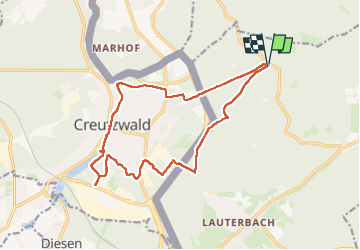
Trail Walking of 15.9 km to be discovered at Saarland, Regionalverband Saarbrücken, Völklingen. This trail is proposed by Francis057.
Positioning
Country:
Germany
Region :
Saarland
Department/Province :
Regionalverband Saarbrücken
Municipality :
Völklingen
Location:
Lauterbach
Start:(Dec)
Start:(UTM)
336143 ; 5454155 (32U) N.
Comments