


sillons la cascade

ninia
User
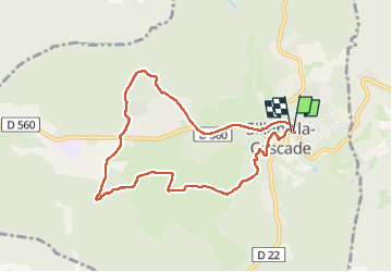

Length
8.6 km

Max alt
458 m

Uphill gradient
175 m
Km-Effort
10.9 km

Min alt
365 m

Downhill gradient
178 m
Boucle
Yes
Creation date :
2023-03-16 08:03:13.084
Updated on :
2023-03-20 11:36:18.544
3h22
Difficulty : Easy

FREE GPS app for hiking
 SityTrail
IGN / Geographical institutes
SityTrail Plus
The world is yours!
About
Trail Walking of 8.6 km to be discovered at Provence-Alpes-Côte d'Azur, Var, Sillans-la-Cascade. This trail is proposed by ninia.
Positioning
Country:
France
Region :
Provence-Alpes-Côte d'Azur
Department/Province :
Var
Municipality :
Sillans-la-Cascade
Location:
Unknown
Start:(Dec)
Start:(UTM)
272399 ; 4827777 (32T) N.
Comments