


Chagny Chassaigne st aubin la rochepot

XavierFaidix
User
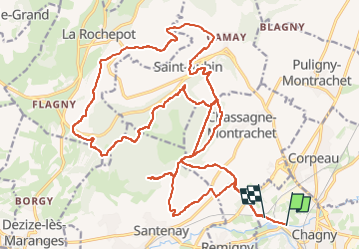

Length
30 km

Max alt
478 m

Uphill gradient
740 m
Km-Effort
40 km

Min alt
202 m

Downhill gradient
737 m
Boucle
No
Creation date :
2023-03-20 12:24:43.58
Updated on :
2023-03-20 16:19:29.914
3h32
Difficulty : Difficult

FREE GPS app for hiking
 SityTrail
IGN / Geographical institutes
SityTrail Plus
The world is yours!
About
Trail Mountain bike of 30 km to be discovered at Bourgogne-Franche-Comté, Saône-et-Loire, Chagny. This trail is proposed by XavierFaidix.
Positioning
Country:
France
Region :
Bourgogne-Franche-Comté
Department/Province :
Saône-et-Loire
Municipality :
Chagny
Location:
Unknown
Start:(Dec)
Start:(UTM)
632694 ; 5196954 (31T) N.
Comments