


Les 40 km de Vallone-PM

tiene
User
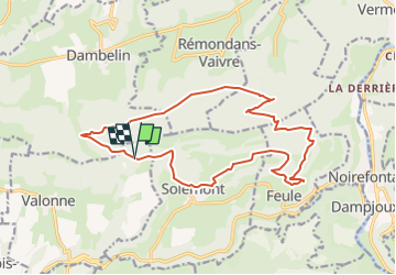

Length
17.2 km

Max alt
781 m

Uphill gradient
702 m
Km-Effort
27 km

Min alt
530 m

Downhill gradient
702 m
Boucle
Yes
Creation date :
2023-03-20 20:53:23.38
Updated on :
2023-04-06 19:22:05.937
6h01
Difficulty : Very difficult

FREE GPS app for hiking
 SityTrail
IGN / Geographical institutes
SityTrail Plus
The world is yours!
About
Trail Walking of 17.2 km to be discovered at Bourgogne-Franche-Comté, Doubs, Valonne. This trail is proposed by tiene.
Positioning
Country:
France
Region :
Bourgogne-Franche-Comté
Department/Province :
Doubs
Municipality :
Valonne
Location:
Unknown
Start:(Dec)
Start:(UTM)
325267 ; 5246985 (32T) N.
Comments