


parioune

Danielba
User GUIDE
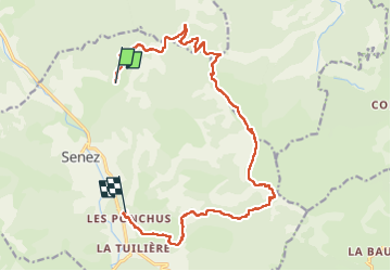

Length
17.2 km

Max alt
1620 m

Uphill gradient
841 m
Km-Effort
29 km

Min alt
811 m

Downhill gradient
975 m
Boucle
No
Creation date :
2023-03-21 07:28:38.434
Updated on :
2023-03-21 15:43:12.782
7h59
Difficulty : Very difficult

FREE GPS app for hiking
 SityTrail
IGN / Geographical institutes
SityTrail Plus
The world is yours!
About
Trail Walking of 17.2 km to be discovered at Provence-Alpes-Côte d'Azur, Alpes-de-Haute-Provence, Senez. This trail is proposed by Danielba .
Positioning
Country:
France
Region :
Provence-Alpes-Côte d'Azur
Department/Province :
Alpes-de-Haute-Provence
Municipality :
Senez
Location:
Unknown
Start:(Dec)
Start:(UTM)
292739 ; 4867382 (32T) N.
Comments