


Craintilleux Montrond bords de Loire

psesjs
User
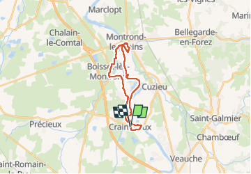

Length
22 km

Max alt
361 m

Uphill gradient
135 m
Km-Effort
24 km

Min alt
337 m

Downhill gradient
134 m
Boucle
Yes
Creation date :
2023-02-08 08:29:54.78
Updated on :
2023-03-22 15:21:23.985
5h23
Difficulty : Easy

FREE GPS app for hiking
 SityTrail
IGN / Geographical institutes
SityTrail Plus
The world is yours!
About
Trail Walking of 22 km to be discovered at Auvergne-Rhône-Alpes, Loire, Craintilleux. This trail is proposed by psesjs.
Positioning
Country:
France
Region :
Auvergne-Rhône-Alpes
Department/Province :
Loire
Municipality :
Craintilleux
Location:
Unknown
Start:(Dec)
Start:(UTM)
596290 ; 5048629 (31T) N.
Comments