


Salvaris Rossilol Barbanche

psesjs
User
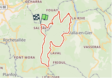

Length
17.3 km

Max alt
1091 m

Uphill gradient
656 m
Km-Effort
26 km

Min alt
629 m

Downhill gradient
655 m
Boucle
Yes
Creation date :
2023-03-22 07:46:01.988
Updated on :
2023-03-22 15:21:30.221
4h46
Difficulty : Easy

FREE GPS app for hiking
 SityTrail
IGN / Geographical institutes
SityTrail Plus
The world is yours!
About
Trail Walking of 17.3 km to be discovered at Auvergne-Rhône-Alpes, Loire, Saint-Étienne. This trail is proposed by psesjs.
Positioning
Country:
France
Region :
Auvergne-Rhône-Alpes
Department/Province :
Loire
Municipality :
Saint-Étienne
Location:
Rochetaillée
Start:(Dec)
Start:(UTM)
615390 ; 5030942 (31T) N.
Comments