


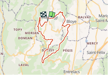
MASSINGY 17 Km

djeepee74
User

Length
17 km

Max alt
693 m

Uphill gradient
514 m
Km-Effort
24 km

Min alt
374 m

Downhill gradient
511 m
Boucle
Yes
Creation date :
2023-03-22 08:39:12.988
Updated on :
2023-03-26 14:04:21.853
5h05
Difficulty : Medium

FREE GPS app for hiking
 SityTrail
IGN / Geographical institutes
SityTrail Plus
The world is yours!
About
Trail Walking of 17 km to be discovered at Auvergne-Rhône-Alpes, Upper Savoy, Massingy. This trail is proposed by djeepee74.
Description
Boucle... live 20230322
Positioning
Country:
France
Region :
Auvergne-Rhône-Alpes
Department/Province :
Upper Savoy
Municipality :
Massingy
Location:
Unknown
Start:(Dec)
Start:(UTM)
726637 ; 5078865 (31T) N.
Comments