


pont phario

pierre67000
User
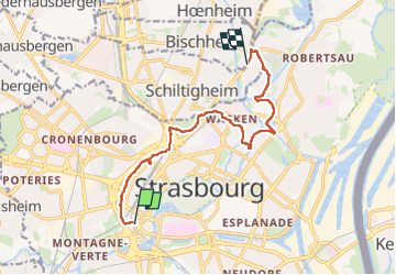

Length
10.4 km

Max alt
149 m

Uphill gradient
97 m
Km-Effort
11.7 km

Min alt
125 m

Downhill gradient
108 m
Boucle
No
Creation date :
2023-03-22 14:21:04.071
Updated on :
2023-03-22 16:42:59.802
2h17
Difficulty : Medium

FREE GPS app for hiking
 SityTrail
IGN / Geographical institutes
SityTrail Plus
The world is yours!
About
Trail Walking of 10.4 km to be discovered at Grand Est, Bas-Rhin, Strasbourg. This trail is proposed by pierre67000.
Positioning
Country:
France
Region :
Grand Est
Department/Province :
Bas-Rhin
Municipality :
Strasbourg
Location:
Unknown
Start:(Dec)
Start:(UTM)
406361 ; 5381228 (32U) N.
Comments