


Saint Germain et exploration !

PatriceCocuaud
User

Length
20 km

Max alt
362 m

Uphill gradient
316 m
Km-Effort
25 km

Min alt
296 m

Downhill gradient
316 m
Boucle
Yes
Creation date :
2023-03-22 14:23:49.644
Updated on :
2023-03-22 16:48:22.575
2h24
Difficulty : Medium

FREE GPS app for hiking
 SityTrail
IGN / Geographical institutes
SityTrail Plus
The world is yours!
About
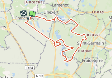
Trail Mountain bike of 20 km to be discovered at Bourgogne-Franche-Comté, Haute-Saône, Franchevelle. This trail is proposed by PatriceCocuaud.
Positioning
Country:
France
Region :
Bourgogne-Franche-Comté
Department/Province :
Haute-Saône
Municipality :
Franchevelle
Location:
Unknown
Start:(Dec)
Start:(UTM)
309548 ; 5290285 (32T) N.
Comments