


G3-Lans station-Col de l'Arc-Conversaria

lionelnottat
User
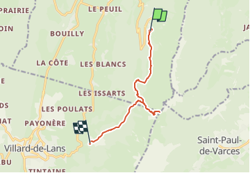

Length
9.7 km

Max alt
1734 m

Uphill gradient
485 m
Km-Effort
16.9 km

Min alt
1173 m

Downhill gradient
714 m
Boucle
No
Creation date :
2023-03-22 18:09:18.074
Updated on :
2023-03-22 18:10:14.82
3h50
Difficulty : Difficult

FREE GPS app for hiking
 SityTrail
IGN / Geographical institutes
SityTrail Plus
The world is yours!
About
Trail Walking of 9.7 km to be discovered at Auvergne-Rhône-Alpes, Isère, Lans-en-Vercors. This trail is proposed by lionelnottat.
Positioning
Country:
France
Region :
Auvergne-Rhône-Alpes
Department/Province :
Isère
Municipality :
Lans-en-Vercors
Location:
Unknown
Start:(Dec)
Start:(UTM)
705196 ; 4998697 (31T) N.
Comments