


col de la boîte serre des aigles chabanas

Joel26400
User
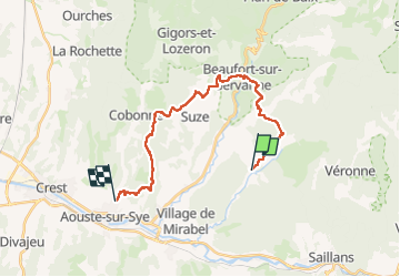

Length
23 km

Max alt
526 m

Uphill gradient
635 m
Km-Effort
32 km

Min alt
224 m

Downhill gradient
830 m
Boucle
No
Creation date :
2023-03-23 07:30:44.131
Updated on :
2023-03-23 15:25:35.419
7h53
Difficulty : Very difficult

FREE GPS app for hiking
 SityTrail
IGN / Geographical institutes
SityTrail Plus
The world is yours!
About
Trail Walking of 23 km to be discovered at Auvergne-Rhône-Alpes, Drôme, Montclar-sur-Gervanne. This trail is proposed by Joel26400.
Description
pas de boucle une traversée
Positioning
Country:
France
Region :
Auvergne-Rhône-Alpes
Department/Province :
Drôme
Municipality :
Montclar-sur-Gervanne
Location:
Unknown
Start:(Dec)
Start:(UTM)
670067 ; 4955830 (31T) N.
Comments